


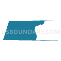
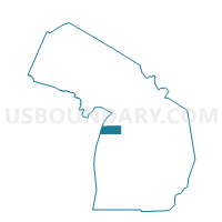
Voting Districts not defined, Benzie County, Michigan
About
Outline

Summary
| Unique Area Identifier | 595996 |
| Name | Voting Districts not defined |
| County | Benzie County |
| State | Michigan |
| Area (square miles) | 511.89 |
| Land Area (square miles) | 0.00 |
| Water Area (square miles) | 511.89 |
| % of Land Area | 0.00 |
| % of Water Area | 100.00 |
| Latitude of the Internal Point | 44.64862130 |
| Longtitude of the Internal Point | -86.49431670 |
Maps

Graphs
Select a template below for downloading or customizing gragh for Voting Districts not defined, Benzie County, Michigan


Neighbors
Neighoring Voting District (by Name) Neighboring Voting District on the Map
- Voting District 0190884000001, Benzie County, MI
- Voting District 0191918000001, Benzie County, MI
- Voting District 0193026000001A, Benzie County, MI
- Voting District 0193218000001, Benzie County, MI
- Voting District 0194424000001, Benzie County, MI
- Voting District 0892600000001, Leelanau County, MI
- Voting District 1010332000001, Manistee County, MI
- Baileys Harbor - T 9999 Voting District, Door County, WI
- WATER Voting District, Kewaunee County, WI
- Voting Districts not defined, Manistee County, MI
- Voting Districts not defined, Leelanau County, MI
Top 10 Neighboring County Subdivision (by Population) Neighboring County Subdivision on the Map
- Frankfort city, Benzie County, MI (1,286)
- Empire township, Leelanau County, MI (1,182)
- Crystal Lake township, Benzie County, MI (957)
- Gilmore township, Benzie County, MI (821)
- Lake township, Benzie County, MI (759)
- Arcadia township, Manistee County, MI (639)
- Blaine township, Benzie County, MI (551)
- County subdivisions not defined, Benzie County, MI (0)
- County subdivisions not defined, Leelanau County, MI (0)
- County subdivisions not defined, Manistee County, MI (0)
Top 10 Neighboring Place (by Population) Neighboring Place on the Map
Top 10 Neighboring Unified School District (by Population) Neighboring Unified School District on the Map
- Benzie County Central School, MI (14,121)
- Glen Lake Community Schools, MI (5,355)
- Frankfort-Elberta Area Schools, MI (3,582)
- Onekama Consolidated Schools, MI (3,267)
- School District Not Defined (Water), WI (0)
Top 10 Neighboring State Legislative District Lower Chamber (by Population) Neighboring State Legislative District Lower Chamber on the Map
Top 10 Neighboring State Legislative District Upper Chamber (by Population) Neighboring State Legislative District Upper Chamber on the Map
Top 10 Neighboring 111th Congressional District (by Population) Neighboring 111th Congressional District on the Map
Top 10 Neighboring Census Tract (by Population) Neighboring Census Tract on the Map
- Census Tract 2, Benzie County, MI (3,150)
- Census Tract 5, Benzie County, MI (3,107)
- Census Tract 4, Benzie County, MI (2,051)
- Census Tract 2, Manistee County, MI (1,933)
- Census Tract 3, Benzie County, MI (1,850)
- Census Tract 9704, Leelanau County, MI (1,760)
- Census Tract 9900, Manistee County, MI (0)
- Census Tract 9900, Kewaunee County, WI (0)
- Census Tract 9900, Door County, WI (0)
- Census Tract 9900, Leelanau County, MI (0)